Continental Marginal Alkali Basalt-Trachyte,
Basanite Phonolites of
Antarctica
|
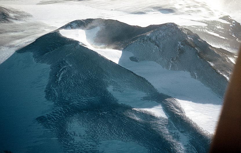
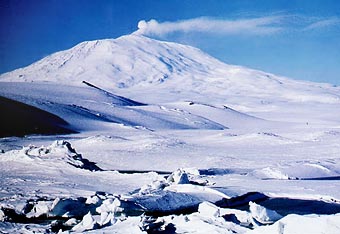
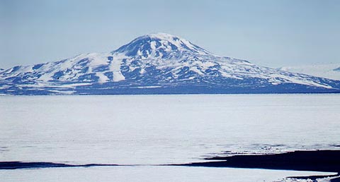
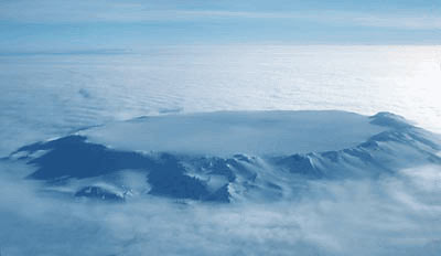
Erebus as seen from Pram Pt, Ross Id,
SW Rift Zone to left. Note the shoulder of an old caldera near the summit but later infilled.
|
 |
|
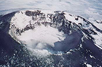
Erebus' crater. Note similarity to Nyiragongo with outer pit crater or caldera, and inner vent. Photo: Antarctic NZ
|
McMurdo Volcanics
Photo supplied courtesy of Antarctic New Zealand
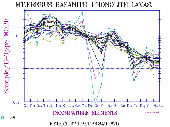
Along both the western and the south-eastern sides of the Ross Sea, Antarctica, are chains of Pliocene to Recent, often eroded, alkali basalt centres with one active centre on Ross Island, Mt Erebus, the only active sodic phonolite volcano in the world. Ross Island lies 70 miles off the Antarctic coast and between is McMurdo Sound. Erebus forms a massive dome 13,000ft high which emits steam. When we flew over the crater in 1956 I was amazed to look down and see circulating red lava in the narrow vent. Erebus has been intensively studied since, there is even a ski-doo road up it. Erebus is famous for its three-inch long crystals of sandine which it ejects in clots of phonolite glass. More normal "Kenyte" lava flow as seen at Cape Evans has 1 inch sanidines thickly set in a greyish fine matrix.
North along an old rift zone lies the smaller and extinct Cape Bird centre, along the eastern rift zone lie a series of adventious and parasitic cones interspersed between Mt Terranova, the 11,000ft Mt Terror, and at Cape Crozier, the "Knoll" with the parasitic cones between them. Along the SW rift zone of Erebus are a chain of small basalt cones, a vent-breccia plug called "Castle Rock", then two more basaltic cinder cones before the rift zone terminates at the trachyte dome of Observation Hill near McMurdo City.
Twenty miles south and south west lie three elongated volcanic islands about 2,000ft high and also of alkali basalt called White, Black and Brown Is.
|
|
Mt Erebus basanite - phonolite, Antarctica. |
 |
Variation diagram for 400 samples of McMurdo and Marie Byrd Land alkaline volcanics from Cape Hallet to Mt Melbourne and Mts Sidley and others. For the largest phonolitic province ever known, data is rather minimal but there appears to be no consistent variation, all are sodic and range mainly from basalt-basanite to trachyte-phonolite. Note the similarity to the Canary Islands with the presense of low Al Pantellerites, however sodic OIBs are quite constant world-wide. |
 |
The rare-earths show a wide range with notably low Nd/La. |
 |
Alkaline Earths show unusually regular trendss, especially in view of the fact that much of this data is now quite old. The Ba peaks at about 1400 ppm at 800 ppm Zr. Note that the low Zr samples show an inversion of Rb and perhaps Nb over Y. Recall that tholeiitic rocks always have Y > Nb-Rb. As there is little erosion except in the largely unsampled Coulman, Franklin and Beaufort Islands it is mainly the youngest rocks which are sampled. Only drilling will reveal how consistent the composition has been with age. |
 |
Metals. Note the increase in Zn with fractionation and lower MgO and the unusual declining Cu. Co is also rather low. Mineralisation is not usually found associated with OIB rocks. |
 |
Th/U Both these elements are unusually high with Th up to >100 ppm, Th/U about 4. Very few provinces have such high U. |
 |
Na-Mg-K Ternary diagram for all McMurdo and MBL Group lavas showing fairly common trends for all even though these forty-odd massive volcanoes and a hundred+ minor centres are spread over a distance of about 1000 miles Again note similarity to the Canary Islands.
|
 |
"The Knoll", an alkali-basalt cinder cone on the eastern flank of Mt Terror, immediately above Cape Crozier and the first discovered Emperor penguin rookery. Taken from the Auster, Sept. 1957. pilot John Claydon. |
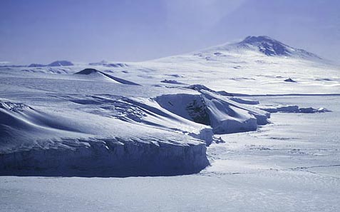
Mt Discovery as seen from Ross Id. The East Rift Zone and Minna Bluff lie to the left. The SW Rift Zone lies behind extending through Mt Morning. A North Rift Zone extends to the right towards Black Id. (Photo: 1958)
About 60 miles SW of Ross Id., Mt Discovery raises its unmodified rounded dome to 9,000ft. It has a prominent ridge-like eastern rift zone extending left which is at least twenty miles long with a prominent rift and superposed small cones terminating at Minna Bluff.
Other related and eroded volcanic islands occur on the western side of the Ross Sea to the north, including Beaufort Id, Franklin Id. and Coulman Island while on the coast N of Terra Nova Bay is the massive Mt Melbourne. More McMurdo Volcanics occur at Cape Hallett and Cape Adair.
Mt Melbourne. Cliffs in the middle foreground appear to be basalt flows.
(Photo: Antarctic New Zealand)
 Near the summit of Mt Melbourne we can see fumaroles hidden within ice chimneys as seen on Erebus, so that Mt Melbourne may also still be active. (Photo: Antarctic NZ) --> Near the summit of Mt Melbourne we can see fumaroles hidden within ice chimneys as seen on Erebus, so that Mt Melbourne may also still be active. (Photo: Antarctic NZ) -->
Worner et al (1985) collected extensively in the Ganovex IV expedition. Their data has rather more trace elements.
|__| Mt Melbourne, mainly alkali basalt, mugearite, benmoreiite, trachyte.
For further information see: Antarctic geology
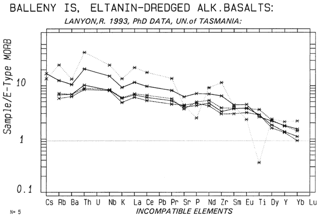
Balleny Is.
300 mi NW of Cape Adare. There is some minor new data by Phil Kyle, no Tr.el. The only complete data is from submarine samples close to the group, (Lanyon, 1993, below). Possibly the Balleny Ids should be regarded as part of the Antarctic McMurdo Volcanics.
 |
Dredged samples from near Balleny Is. These are probably similar to the islands themselves. |
In the northern centre of the Ross Sea is a plug of phonolite forming Scott Island.
Marie Byrd Land Volcanics
On the eastern side of the Ross Sea lie a similar series of large alkali basalt domes, usually partly buried in ice and following north-south or east-west chains. In one case only the summit caldera is visible. So far we have mainly only major element data on these rocks but Masurier & Rex include all but the heavy REE. However, their data is the result of collections from more than 20 volcanoes and the scatter is large.
With 17 massive alkali-basalt phonolite centres all partly buried in ice now recognised, these fault oriented and no-longer active centres are one of the greatest alkali-basalt provinces world wide.
Historical Note. Oddly, this is one of the few major formations I once named which have retained the name without my ever seeing them. We once set off full of good intentions, some mountains having been reported by Byrd, in 1937. A lot of bad weather and three crashed aeroplanes later we withdrew without having sighted one of them!
Mt Hampton, an alkaline volcano in Marie Byrd land almost buried in ice.
Photo: Britsh Antarctic Survey
 |
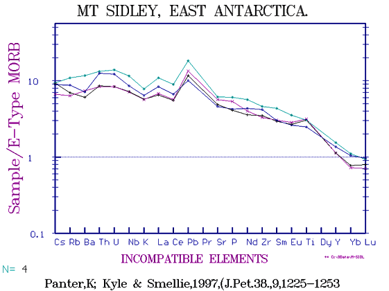
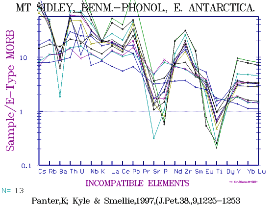
Alkali Basalts of Mt Sidley. |
 |
Mugearites-trachy phonolites of Mt Sidley. |
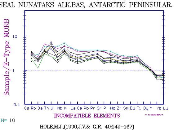
Some alkali basalts also occur on the other side of the continent on the south-eastern side of the Graham Land Peninsula, including Seal Nunataks.
 |
Seal Nunutaks, Alkali basalt islands on the eastern side of Graham Land, Antarctic Peninsula. |
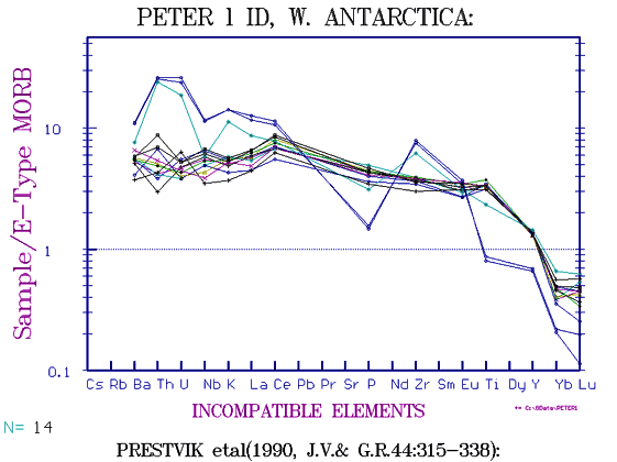
Peter 1st Island
 |
Peter 1st Id., W.Antarctica.
Note unusually low HFSE (Heavy REE etc,) |
This isolated island lies east of the Ross Sea and about 350miles west of Graham Land Peninsula and inside the Antarctic Circle.
Click for requests or comments:
Copyright © 1998-2003 Dr B.M.Gunn
BACK
|