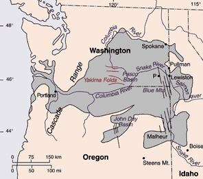
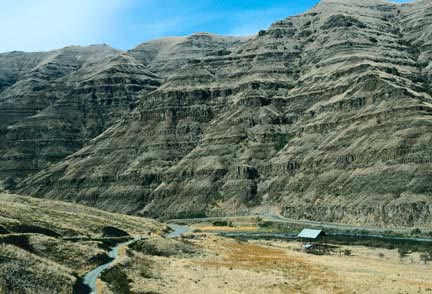
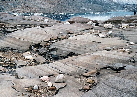
(and Layered Intrusions) Columbia River Basalts (USA) Thanks mainly to the work of Dr Peter Hooper at WSU and his associates these are perhaps the best known of all the flood basalts. Hooper claims that the Roza centre twice erupted 700 cubic km within a few days 15,000,000 years ago, forming a flow with a length of 190 miles (300km), an area of 15,400 sq miles (40,000 sq km), while the Pomona member flowed an even greater distance of 600km to the Pacific Ocean.
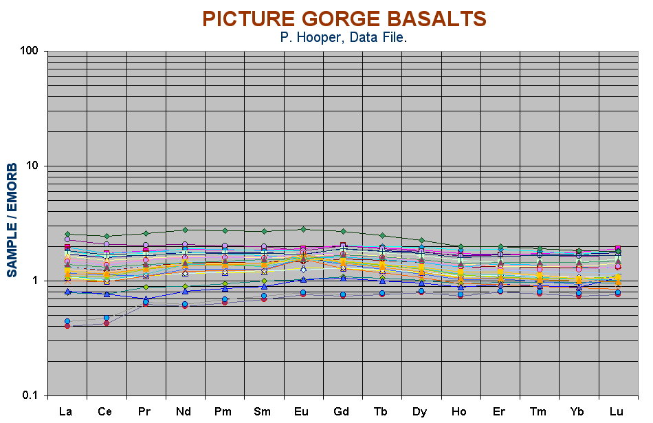
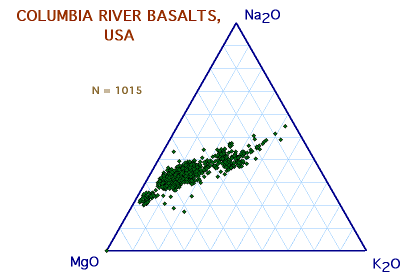
Like the Gondwana flood basalts, the CRBs are similar to MORBs in their major element characteristics but have greatly elevated K, Rb, Ba and LILE with depleted Nb-Ta, and they are divisible into a dozen magma types on their characteristic chemistry. Some of the lava groups, eg the Prineville Basalts and the Umatilla series plot in the Hawaite-Mugearite areas of an alkali-silica diagram but this is due to their enhanced K content. They do not fall into the "Basalt Triangle" on a Al-Mg-Ca diagram but above it, and they are extremely potassic as may be seen in the ternary diagram below. Their signatures vary from similar to a rather mature island arc andesite type (Picture Gorge, Powder River Group, Imnaha Basalt, Wanapum Basalt) to a more enriched form with Rb at 8-10 times E-type basalt, (Prineville, Grande Ronde, Roza) with the extreme being seen in the Umatilla Basalt which may have only 5-12 times Rb but is very enriched in Ba (50-60 times E-type) as well as in P and Zr. This means that Umatilla has 2700 to 4000 ppm Ba cf 140-430 Ba for the Imnaha rocks while Zr is at 400-500 ppm cf 120-230. Fortunately some new REE data has become available for Umatilla, these being among the most Ba (and Zr, P) enriched basalts known. In the western USA, this characteristic andesite-like signature is not confined to Columbia River Basalts. Similar rocks may be seen elsewhere in part of what is termed the Basin and Range province, eg in the Elkhead Vol. Field in SW USA, (Leat, et al, 1988, JGR 102) where the rocks have a typical orogenic signature but have acquired more K (and Ba) than soda and plot in the Hawaiite-mugearite fields, however, Ti as well as Nb remain low. Other continental basalts showing a similar signature include Walton Peak (Thompson, et al, J.Geol.Soc.S.L., 150), the Flattop field, (Gibson et al, 1991, JGR 96). Some of these Basin and Range lavas may therefore also be CFBs. In the "GEOROC" database, these are included in the Columbia River group, along with the Snake River basalts, the Craters of the Moon and even the Yellowstone-Shoshone Mtn lavas, the latter being a somewhat doubtful association as these are undoubtedly calc-alkaline. Odd chemical compositions might be expected in basalts of the Washington-Oregon area, where an offshore ocean-spreading ridge (the Gorda Ridge) sends major transcurrent faults under the continent,. This does not however explain the unusually high Ba enrichment or the highly variable P and Zr nor the fact that exactly the same variations are seen in other continental basalts from a wide range of tectonic environment. All are however associated with subductions zones forming under or being underthrust under continents, and the high Ba must be associated with sub-continental mantle enrichment by older subduction processes. Picture Gorge subgroup of the CRB's
The Grand Ronde field can be identified on the combined CRB diagram above. Steens Mountain, Oregon
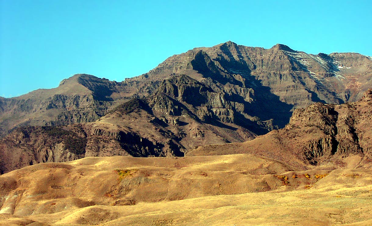
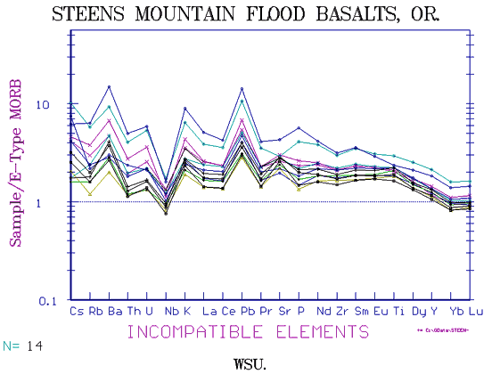
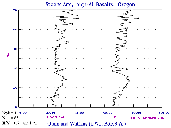
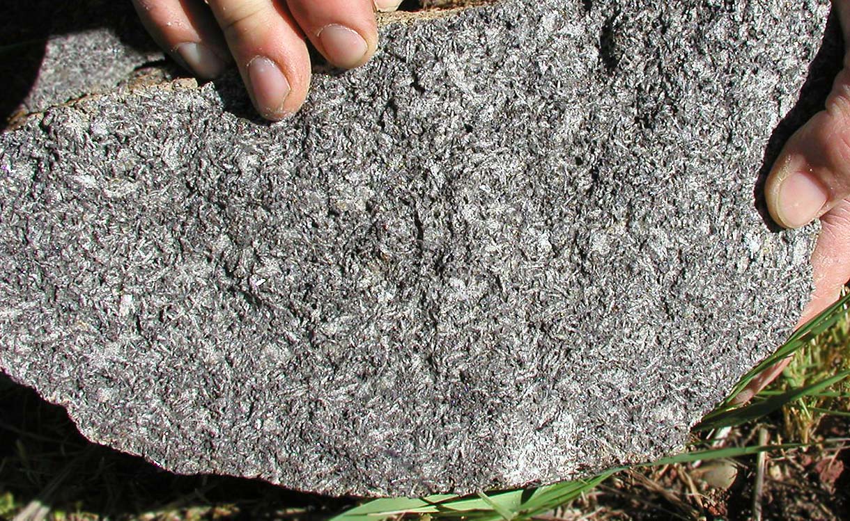
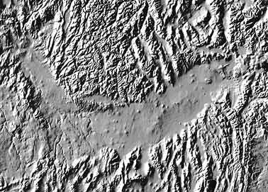
Steens Mountain is a centralised Flood basalt subprovince of 16.6M year age closely allied to the Columbia River Basalts and lying in southern Oregon. An excellent cross-section is on view due to the centre being cut by a Basin and Range fault which has created a NNE-trending, east-facing scarp about 3200ft (1000m) high, one of the greatest vertical exposures of Tertiary basalt known. Related flows may have once covered 25,000 to 50,000 km2 but effusion finally centred near the crest of the present Steens Mtn, forming a shield volcano. In the early 1970's the late N.D.Watkins and I began a study, in the hope that such a large lava pile would reveal mantle depletion effects in late compared to early stages. Watkins sampled by diamond drill some 70 lava flows of a total of perhaps 100 ranging from 1-10 m thick, taking four samples per flow. Steens forms the surface expression of a presumed large fractionating magma chamber, which periodically expelled highly feldspar-phyric magmas. Plagioclase is the main phenocrysts phase (as in most ORBs) followed by much finer-grained olivine, at least no coarse olivine has been expelled. The plagioclase probably floated and was largely extruded with some flows including up to 50% feldspar phenocrysts sometimes up to 4cm long. The Sc content remains constant showing little or no clinopyroxene formed. Other flows are quite aphyric. Extensive olivine fractionation is indicated by the trend of increasing Fe/Mg from bottom to top and the strongly decreasing Ni and Cr. No olivine cumulates or picrites were extruded however, the most magnesian rocks in our study having 7% MgO and in a later study by J. Johnstone of WSU, 12%. The magma chamber below must therefore now include extensive peridotite. Residual elements not included in either olivine or plagioclase, eg Cs, Rb, Ba, Th, U, Nb, La, K and light REE increase steadily towards the top of the lava pile while feldspars become more sodic and ferro-magnesians more iron-rich, an excellent example of "hidden layering" . Nickel variation is wide, 5 - 345ppm, yet the correlation with MgO is unusually poor which may indicate sulfide mineralisation. Olivines in section are limited to a few grains and normatively to only 8.25% in the most magnesian rock. A little below the centre of the series there occurs an odd "mafic zone" of 15 flows of higher MgO, averaging about 8% compared with 7% near the base and 2.3% at the top of the mountain. In our original paper (Gunn & Watkins, 1970, GSAB 81) this is termed the "E" group. This horizon may be seen in other sections, eg between 7200ft and 7600ft in Johnstone, (1999). Calculated CIPW Norms show the lower lavas to have an An51 plagioclase compared with An57 in the mafic zone and An27 at the top. Ferro-magnesian ratios for minerals are 78.5 in the mafic zone and 61 and 50. The most plagioclase-rich sample recorded came from above the mafic layer and had An57.5 with a total plagioclase content of 76%. However, with 1-inch drill cores and 4 cm plagioclases, such a mode has little meaning. The REE show a divergence toward the light REE end. La/Lu ratio varies from 28.5 in the mafic zone to 41.7 at the base to 63 at the top. Johnstone (1999) therefore erred when it was stated "Rare Earth and trace element patterns throughout the sequence are similar"! Though not shown in our original paper, a Ni/Ba diagram shows Ni decreasing from 260 ppm to 5 while Ba increases from a low of 300 ppm to almost 1000 ppm in some upper flows. If we note that the plagioclase is considerably more sodic and the ferromagnesians more Fe-rich than is seen in layered flood basalts of the British Tertiary, we might be tempted to guess that a considerable volume of more calcic and magnesian magma was not erupted. Such a basic gabbroic intrusion might well be heavily Cu-Ni mineralised.
Further Work Steens has perhaps been already subject to undue attention, but as it has the greatest number of exposed flood basalt lavas known together with the fact it is perhaps the only exposed "layered extrusion" known and has the same "allivalite" fractionation patterns (Ol + Plag) seen in the British Tertiary, still more could be learnt. What is the range in composition of single flow members both vertically and in length? What an unparalleled opportunity to study feldspar compositions and their effects on fractionation! Why are some flows described as "highly altered"? This usually suggests different chemistry. How deep down does the now solidified peridotitic magma chamber lie?
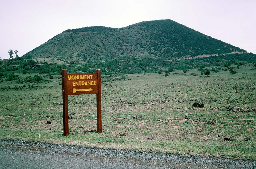
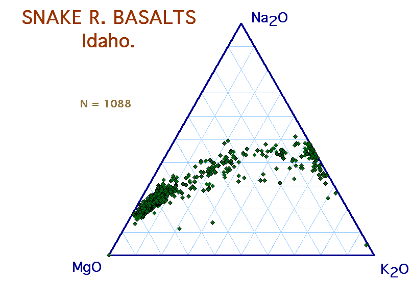
The Snake River Basalts The Snake River Plains lie in a boomerang-shaped fault depression extending east from the eastern edge of the Columbia River Basalts for 400 miles to the edge of the rhyolitic caldera of the Yellowstone thermal area. The rocks are mainly very flat-lying basalts with occasional associated rhyolites while the very youngest cinder cones at the “Craters of the Moon” national park fall in the hawaiite-mugearite fields on an alkali/silica diagram. The ages range from 15myr at the west, (approximately the same as the youngest CRBs) and reportedly young to the east with the 2 ka Craters of the Moon lie in the middle of the eastern sector.
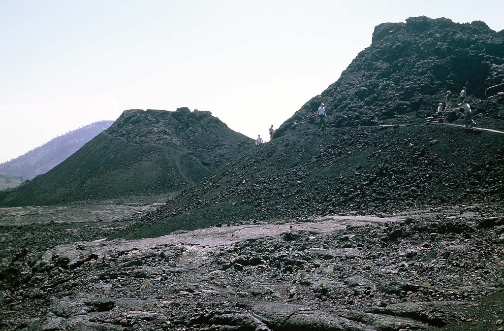
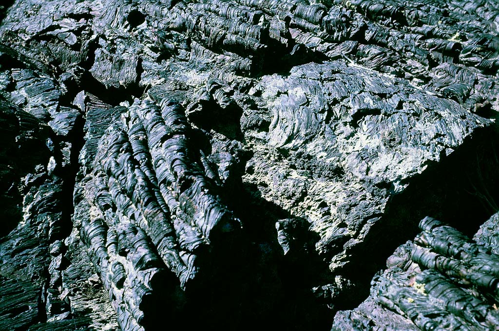
Drilling and seismic work show, according to the USGS, the maximum thickness of the older flows to be in excess of 4000ft, so that very roughly, about 60,000 cub.km.of lava must be present. Flows have mainly pahoehoe surfaces though the glass “skin” has been etched away by wind-blown dust. Fissures lie open, one of the youngest shows a levee enclosing an area of a square mile from which most of the lava has drained back. Down in one of the fissures at a depth of 200ft ice lies in the hottest summer.
Lava which flowed into pre-existing stream and lake beds formed porous pillow lava and tuff which now act as channels by which aquifers drain into the Snake River Canyon. We had a rather amusing experience, too long a story to relate in detail, when the Idaho Nuclear Research Station (located about 20 miles from Pocatello) chief asked me to give a talk to some of the technicians on how to locate aquifers for which they were drilling, without a very good success rate. It turned out they saw an aquifer as a good way to dispose of unwanted radioactive nuclear waste. They were not geologists and it had not occurred to them that water at a depth of several hundred feet could ever come to the surface. It had not occurred to them either that the water-falls cascading from between the flows into the Snake were those same streams and they were proposing to pour radioactive waste into the drinking-water supply for Lewiston, Clarkston, Portland, Sanfrancisco and in fact a good proportion of the western US. Challenged to suggest an alternative I could only suggest the opposite, a desert area in a tectonic depression which was seismically stable such as Death Valley where there could be no fear of concrete enclosed waste ever getting below a water table. The waste disposal unit for the USA is in fact now located on the edge of Death Valley, so I hope it pans out.
Lava Compositions of the Snake River Basalts
As yet (year 2000) there is (was) surprisingly little data. Leeman and Vitaliano (1976, BGSA 87, 1777-92) show 16 ME analyses of a compact group of high K basalts some showing marked Fe enrichment. Tilley and Thompson (1970) and George Stone of the USGS (unpublished data, circa 1967) showed a wider range varying from 44-48% SiO2 and I analysed some hawaiites from Craters of the Moon (unpublished). Lum and Leeman (1989, JGR, B94, 7871-84) and Honjo and Leeman (1987, C.Min.Pet. 96, 163-167) added trace elements and some REE. The data is now rather old and there is a good deal of scatter. In general they show the high K and Ba with REE equal to or greater than EMORB levels as have most CFB’s, but except possibly for the most basic, no negative Nb-Ta anomaly is seen. As we have seen, this is an invariable characteristic of CFBs, there being no exceptions. Two more detailed though old analyses by Thompson et al, 1983, ("Continental Flood Basalts”) also give a low Zr/Nb of 11. However the presumably related Steens Mountain and Columbia River Basalts are notoriously variable and at least one characteristic, the very high P seen especially in the Umatilla series is also seen in Snake River where it reaches 2%.
Geist et al, (2001, Geol.Soc.Amer.Sp. Pap. 353) presented data from drill cores from the north-eastern extremity of the group and are also puzzled by the high P2O5 content and suggest the possibility of crustal contamination, though their highest P2O5 is only 1%. Their MORB normalised diagrams again show a more OIB-type fingerprint, not a typical CFB one.
Iron is high at 16% and TiO2 is unusually high even for CFBs at 4% with some indication of two levels being present. Again this matches the Umatilla rocks of the CRB. Rhyolites are very potassic (6% K2O) but seem to be related to the basalts and intermediate rocks though the extensive ignimbrites of the Yellowstone region are almost certainly of refused crustal keel material and there is a mineralogical suggestion of hybridisation. A group from the University of Utah headed by Dr John Shervais are making a new study of the Snake River and we may hope to see new data by early 2004. The Idaho Geological Survey also have 400 new analyses in the publication process. In general, the high iron enrichment of the tholeiitic type and the high Ba and P suggests a CFB affiliation in the older rocks. The reversion to an alkaline type in the closing stages seems similar to that seen in Mauna Kea (Hawaii) where after the cessation of the shield-building tholeiitic stage and a considerable time hiatus, superficial monogenetic alkaline rocks are extruded. No fingerprints are as yet available for the olivine tholeiite-type rocks of the 9 – 7 ma period (Bonnishchen et al, see NET page).
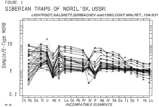
Lightfoot et al (1990, 1993) show the Siberian Traps to be similar to the CRB's. Unfortunately Ba was not determined, and the wide range of Rb may suggest some alteration. Six magma types are present ranging from tholeiitic to alkali-basalt. Carbonatites are also found associated with these rocks. At minimum the Siberian Traps of the Norils'k area cover 1,000,000 sq km but related areas have either been buried or removed by erosion. These rocks are now a major source of nickel and also of PGE's.
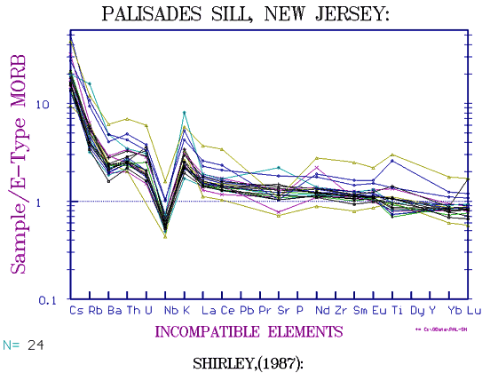
The Palisades Sill (USA) The Palisades form an extensive 1000ft-thick dolerite sill lying along the western side of the Hudson River, west and north of New York. Being so prominent it has been the focus of a good deal of primary study. It is of typical Flood Basalt composition being rather high in K, Ba (x2 - x4 times MORB) and what data are available suggest it is of similar composition to the geochemical standard rock W-1, the Centerville Diabase from near Washington DC which is I believe of the same age. Walker (1940, BGSA 51) of Walker & Poldervaart fame, decided that the variations in the sill, including the well-known olivine ledge near the base, was due to olivine-clinopyroxene fractionation with the heavy olivines settling to the bottom and attributed the lack of any smooth compositional variation diagrams to the fact that clinopyroxene had about the same silica content as the average rock. Pearce (1969, J.Pet 11) ratioed the major oxides to Al2O3 which then showed fair agreement in diagrammatic slope with olivine and clinopyroxene. In the same era or a little earlier (1955-65) I was also somewhat baffled by the erratic compositional nature of the Antarctic Ferrar Dolerite sills, but found that element variation diagrams described ellipses, not straight lines or simple curves, the reason being that two points of similar Mg contents in the lower and upper parts of a sill, will have different LILE/HFSE ratios. Plotting several overlapping ellipses from different locations does indeed produce a profusion of apparently scattered points Plotting element concentration against height also showed that all the larger Ferrar Dolerite sills were multiple injections. I tested the same theory on the Palisades sill and found that the bulk average composition of the sill was much higher in Ca, Al etc that the average of the upper and lower chilled margins, the magnesian olivine ledge being only ten feet thick. Like the Ferrar Sills it must have been multiply injected by magmas of different composition, on top of which was superposed fractionation effects, the lower parts of the sills always being more magnesian that the upper parts. As the Palisades Sill was by this time regarded as the classic example of insitu fractionation, I had considerable trouble defending my dissertation! In about 1970 I spoke to Dr Ken Walker who, using an electron microprobe, found two distinct generations of olivines, which indicated multiple injection again. In about 1990, Mathew Gorring of Columbia University, did his doctoral thesis on the sill, and sent me his results which included some trace elements, (Ni, Co, Cr, Ba, Cu, Zr etc) Mathew did two sections, but only of the lower 100ft across the olivine layer, at Fort Lee and at Alpine, N.J. The latter is somewhat more magnesian but the trends are the same. An oddity lies in the fact that which Ni/MgO and Co/MgO diagrams show the usual gentle curve, but Cr/MgO shows an inverted "V", the highest magnesian rocks having about half the Cr of the intermediate rocks(450 ppm vs 900), Clinopyroxene of course contains much higher Cr than olivine, but this is usually masked by the inclusion of Cr spinels. It seems any chrome spinel must have been dropped out before the intrusion of the olivine ledge. Another PhD student, Shirley by name, sent me data in 1987 of a large number of ferro-basalts and granophyres terminating in highly fractionated rocks of FM#96, though only 62% SiO2. Unfortunately he did not send any location data, but we now have a compositional range from 25% MgO down to about 0.2% and can produce quite repectable variation diagrams. As the only granophyre previously reported was a single thin late-stage dike, one would love to know where he found them. Mathew Gorring also analysed some olivines, all very iron rich at Fo72 to Fo55, but the picrite trend in the sill does not 'point' to these olivines but to a more magnesian but still unusually iron-rich one of about Fo80. They must be the most iron rich 'picrites' known except for the Shiant Sill. One can only assume MG did not find the most magnesian olivines. So it seems there are still some mysteries to be cleared up about the Palisades Sill. I have never seen the data of Gorring or Shirley in print or referred to, but presumably it rests in some archive at Columbia U. Recently we found that Shirley's data did include REE which had been overlooked and though no Zr, Nb or Y, it does include Ta; so using the constant Nb/Ta = 15, we have added some Nb values. The results show that the Palisades are formed of a typical Flood Basalt, rather like Grande Ronde in the CRB's, but less enriched in LILE than are the Ferrar Dolerites. It is moreover a virtual match for the standard Centreville Diabase rocks, W-1 and W-2 even to the rather high Cs. Pb is not included in Shirley's data but is oddly high in W-1 accepted levels.
Greenland The Skaergaard Intrusion is composed mainly of cumulates and chilled margins vary within inches. Producing a good chilled margin fingerprint is therefore difficult to impossible. This is probably the best developed and best known layered intrusion world-wide of peridotite, troctoliite, anorthosite, pyroxenite etc. The chemisry of any layered rocks is wildly variable, there is no recent TE data and chemically speaking we do not learn much from Skaergaard in spite of it's wonderful mineralagy and petrographic texture.
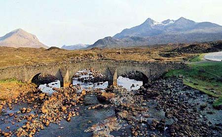
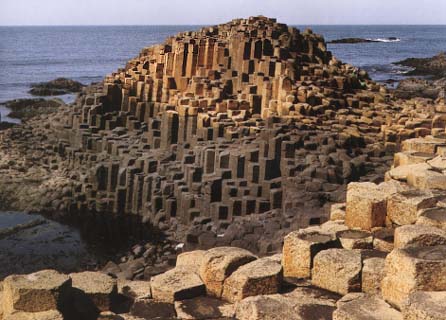
The Hebridean (British Tertiary) Basalts From recent data these are certainly Continental Flood basalts and should be included here,
Unfortunately, while not metamorphosed as the Archaean flood basalts have been, there has been deep glacial erosion and more than a million years of rain, so that really fresh sample in the British Tertiary is the exception rather than the rule. Originally grouped in the "Brito-Arctic" province including Greenland, Iceland, the Faeroes and Jan Mayen, (see Turner & Verhoogen, 1960, McGraw Hill, p222), we now know that while some of the basalts of East Greenland are rather similar to OIBs such as Mauna Loa, (see Thirwall et al, 1994, J.Pet. 35 for the Hold-With-Hope basalts), the bulk of the East Greenland rocks appear to be Flood basalts, see Hald et al, 2000, Lithos 54, for the Jameson Land Basalts) though the chilled margins of the Skaergaard Intrusion, (Hoover, et al. 1989, (J.Pet.30) are highly variable and not distinctive. Iceland of course is composed of simple MORBs, differing only in the presence of higher fractionates such as rhyolite which may be due the much greater local crustal thickness, allowing extensive fractionation to take place in sub-crustal chambers. Jan Mayen is a potassic ankaramite-basanite-trachy-phonolite platform while the Faeroe basalts are a repeat of Iceland. So what are the Hebridean lavas? Many people have claimed the presence of picrites in the Hebridean rocks but they prove to be of erratic composition with a few samples of 25-30% MgO but with a wild association of Mg, Cr and Ni and again seem to be simply occasional random Ol+Cpx cumulates. (eg, see Gibson et al, 2000, E.P.S.L. 174, 366-376). Fergus Gibb et al (2006, J.Pet. 47, 191-230) have shown that the Shiant Sill on an island midway between Skye and Harris-Lewis is a multiply injected ferro-picrite sill. In spite of the iron-rich olivines the Zr/Nb is > 30 and the La/Sm in the range 1-2 suggesting extensive pre-injection fractionation.
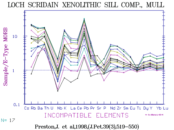
Some of the Hebridean lavas are tholeiites, some olivine basalts, some alkali basalts and even trachytes. Unfortunately there is no recent data for the high-soda mugearites of Mugeary on Skye. The general fingerprint resembles an EMORB in the many cases where little or no trace element data is available and Nb especially is lacking. We can say definitely they are not MORBs, rarely are they truly alkaline (the Nb for example is too low and the Nb/Zr far too low for such enriched rocks. All show considerable fractionation and they are not a partial melt series, their trend often being at right angles to a partial melt trend. The odd composition has been explained by some authors as being due to ingestion of Lewisian gneiss and shale by MORB basalt, but the low Nb, frequently less than 1ppm at 9% MgO cannot be explained by the addition of a few percent of shale when we regard that these rocks are in general quite enriched in LILE. Their similarity to other Flood Basalts, eg of Antarctica, is marked. The eroded roots of old shield volcanoes are seen in Skye, Rhum, Canna, Ardnamurchan etc with strongly layered intrusive gabbros with peridotite and anorthosite (troctolite-allivalite) banding.
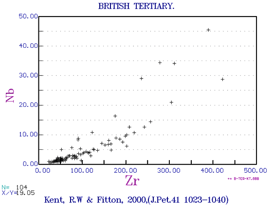
The North Atlantic CFB Province All the basalts of the British Tertiary, the Faeroes, Iceland, the MAR, East Greenland and Eastern USA were once looked on as a single basaltic province. We now know that CFB’s of the British Tertiary and East Greenland are quite different to the OIB’s of Iceland which are different, (though in some cases very slightly) from the MORBs and NMORBs of the Neo-volcanic zone of Iceland as well as the Mid Atlantic Ridge. Being all generated by partial melting of the upper mantle there are similarities, but the British-Tertiary and East Greenland basalts are generated in the sub-continental Upper Mantle and are so contaminated and enriched by the products of old and no-longer active subduction zones. GEOROC have combined the basalts and Dike swarms of East Greenland with the British Tertiary so we will show them here together, but at some time in the future we may show East Greenland separately.
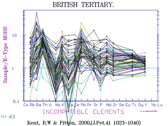
There are many allivallite-troctolite etc cumulates in the central volcanoes of the British Tertiary, and some plateaux lavas are quite alkaline as in Snake River Plains ( though not as P-rich). However the general pattern is typically CFB, with high K2O (+Rb, Ba, Cs, LREE) and the fingerprints are classic Nb-Ta depleted. Low grade alteration is also unfortunately a common feature in British Tertiary rocks. Although 1400 samples have been analysed for REE, there is a wide scatter between tholeiitic and ultra-alkaline members so these are not shown though they reach from 2 - 200 ppm La in the more extreme cases.
V shows the usual MORB pattern peaking at 5-6% MgO at 450 ppm, but is unusually high (300 ppm) in the picritic rocks.
Isotopes are extremely variable as could be expected of rocks of such mixed parentage, with Sr87/86 ranging from 0.702 to 0.716, while leads show a greater range than all the oceanic rocks combined.
Copyright © 1998-2006 Dr B.M.Gunn |
|||||||||||||||||||||||||||||||||||||||||||||||||||||||||||||||||||||||||||||||||||||||||||||||||||||||||||||||||||||||||